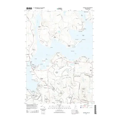
2014 Map of Salsbury Cove
USGS Topo · Published 2014About this map
Mount Desert Island and the mainland shore of Trenton are linked by the Trenton Bridge, illustrating the modern transportation network serving this coastal corridor. On the island, the expansive boundaries of Acadia National Park dominate the landscape, protecting diverse terrain from the heights of Youngs Mtn to the shoreline at The Ovens. The map documents a complex human geography through its numerous small burial sites, including the Emery Family Burial Ground and the Higgins Marcyes Burial Ground, which reflect deep-seated family roots in the Salsbury Cove and Town Hill areas. On the mainland, the Hancock County-Bar Harbor Airport stands as a significant landmark near Lamoine Corner and East Lamoine. This survey effectively captures the transition between organized settlements like Bar Harbor and the protected wilderness of the interior, marked by features such as Frenchmans Hill and Eagle Lake.
Find a feature on this map
133 named features on this map. Tap any name to fly to it.
Don’t see what you’re looking for? This feature index may not catch every label — zoom into the map to look around manually.
Map Details
Editions of this 2014 Salsbury Cove Map
This is the sole edition of this map. No revisions or reprints were ever made.
Other maps of this area

1904 · Mount Desert
USGS Topo · 1:62,500

1904 · Bar Harbor
USGS Topo · 1:62,500

1911 · Ellsworth
USGS Topo · 1:62,500

1930 · Tunk Lake
USGS Topo · 1:48,000

1932 · Tunk Lake
USGS Topo · 1:62,500

1940 · Ellsworth
USGS Topo · 1:62,500

1942 · Bar Harbor
USGS Topo · 1:62,500

1942 · Ellsworth
USGS Topo · 1:62,500

1942 · Mount Desert
USGS Topo · 1:62,500

1942 · Tunk Lake
USGS Topo · 1:62,500