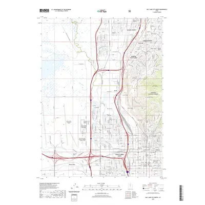
2020 Map of Salt Lake City North
USGS Topo · Published 2020About this map
The Jordan River flows northward through a landscape of heavy industrial and transit infrastructure where the Salt Lake Valley meets the foothills of the Wasatch Range. This modern survey details the dense urban and suburban corridors of Salt Lake City, North Salt Lake, and Bountiful, showing the complex intersection of the Legacy Parkway and Surplus Canal. Notable for genealogists are several historic burial grounds, including the Sessions Settlement Pioneer Cemetery and the Brigham Young Family Memorial Cemetery. The map also highlights significant civic and religious landmarks such as the Cathedral of the Madeleine, the Matheson Courthouse, and the Utah Supreme Court. To the west, the massive footprint of the Salt Lake City International Airport dominates the valley floor, while the eastern edge is defined by the steep rises of Ensign Peak and Meridian Peak within the Wasatch National Forest.
Find a feature on this map
47 named features on this map. Tap any name to fly to it.
Don’t see what you’re looking for? This feature index may not catch every label — zoom into the map to look around manually.
Map Details
Editions of this 2020 Salt Lake City North Map
This is the sole edition of this map. No revisions or reprints were ever made.
Other maps of this area

1885 · Salt Lake
USGS Topo · 1:250,000

1885 · Tooele Valley
USGS Topo · 1:250,000

1925 · Ft. Douglas
USGS Topo · 1:125,000

1928 · Ft. Douglas
USGS Topo · 1:125,000

1950 · Fort Douglas
USGS Topo · 1:24,000

1951 · Fort Douglas
USGS Topo · 1:24,000

1951 · Saltair
USGS Topo · 1:24,000

1951 · Salt Lake City South
USGS Topo · 1:24,000

1951 · Salt Lake City North
USGS Topo · 1:24,000

1952 · Saltair NE
USGS Topo · 1:24,000