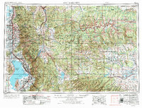
1958 Map of Salt Lake City
USGS Topo · Published 1958About this map
The Wasatch Range forms the towering spine of this mid-century survey, dividing the rapidly growing urban corridor of the Salt Lake Valley from the high timber of the Wasatch National Forest and the Uinta Mountains. To the west, the infrastructure of the Wasatch Front is clearly defined, showing the expansion of Salt Lake City and Murray alongside industrial landmarks like the Kiegley Limestone Quarry and Fort Douglas Military Reservation. Water management is a dominant theme, illustrated by the presence of Strawberry Reservoir, Deer Creek Reservoir, and the Murdock Pumping Station, which supported the region's agricultural and municipal needs.
Find a feature on this map
253 named features on this map. Tap any name to fly to it.
Don’t see what you’re looking for? This feature index may not catch every label — zoom into the map to look around manually.
Map Details
Editions of this 1958 Salt Lake City Map
This is the sole edition of this map. No revisions or reprints were ever made.
Historical Maps of Hillcrest Park Through Time
4 maps found