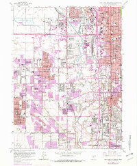
1963 Map of Salt Lake City South
USGS Topo · Published 1979About this map
Salt Lake City and its southern suburbs are captured here during a period of significant mid-century expansion, dominated by the heavy infrastructure of the Jordan River valley. The landscape is a dense network of water management and transportation, featuring the Surplus Canal, Utah and Salt Lake Canal, and extensive Settling Ponds in the northwest. Industrial and social hubs are clearly marked, from the County Fairgrounds to the County Hospital and St. Joseph Home.
Find a feature on this map
84 named features on this map. Tap any name to fly to it.
Don’t see what you’re looking for? This feature index may not catch every label — zoom into the map to look around manually.
Map Details
Editions of this 1963 Salt Lake City South Map
4 editions found
Other maps of this area

1885 · Salt Lake
USGS Topo · 1:250,000

1885 · Tooele Valley
USGS Topo · 1:250,000

1925 · Ft. Douglas
USGS Topo · 1:125,000

1928 · Ft. Douglas
USGS Topo · 1:125,000

1950 · Fort Douglas
USGS Topo · 1:24,000

1951 · Fort Douglas
USGS Topo · 1:24,000

1951 · Saltair
USGS Topo · 1:24,000

1951 · Salt Lake City South
USGS Topo · 1:24,000

1951 · Midvale
USGS Topo · 1:24,000

1951 · Salt Lake City North
USGS Topo · 1:24,000