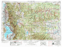
1980 Map of Salt Lake City
USGS Topo · Published 1988About this map
Salt Lake City and its surrounding mountain valleys are captured here during a period of significant suburban expansion along the Wasatch Range. The map documents the dense urban grid of the city and its neighboring communities like Murray, Holladay, and Bountiful, which are increasingly interconnected by the rising systems of Interstate 15 and Interstate 215. East of the city, the landscape shifts dramatically into the high terrain of the Wasatch National Forest, where steep canyons like Parleys Canyon and Big Cottonwood Canyon provide critical water resources and recreation areas.
Find a feature on this map
131 named features on this map. Tap any name to fly to it.
Don’t see what you’re looking for? This feature index may not catch every label — zoom into the map to look around manually.
Map Details
Editions of this 1980 Salt Lake City Map
3 editions found

Historical Maps of Salt Lake City Through Time
4 maps found