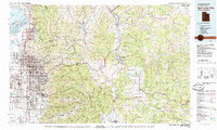
1980 Map of Salt Lake City
USGS Topo · Published 1985About this map
The Wasatch Range dominates this 1980 survey, illustrating the sharp contrast between the dense urban sprawl of Salt Lake City and the mountainous terrain to the east. The map documents the extensive transportation network of the era, from the major corridors of I-15 and I-80 to the historic rail lines of the Union Pacific and the Denver & Rio Grande Western. This edition captures the valley's post-war expansion, showing established suburban communities like Holladay, Murray, and Granger as they appeared before the massive growth of the late 20th century.
Find a feature on this map
101 named features on this map. Tap any name to fly to it.
Don’t see what you’re looking for? This feature index may not catch every label — zoom into the map to look around manually.
Map Details
Editions of this 1980 Salt Lake City Map
3 editions found
Other maps of this area

1885 · Salt Lake
USGS Topo · 1:250,000

1885 · Uinta
USGS Topo · 1:250,000

1885 · Tooele Valley
USGS Topo · 1:250,000

1900 · Coalville
USGS Topo · 1:125,000

1901 · Hayden Peak
USGS Topo · 1:125,000

1903 · Hayden Peak
USGS Topo · 1:125,000

1903 · Coalville
USGS Topo · 1:125,000

1907 · Strawberry Valley
USGS Topo · 1:125,000

1909 · Strawberry Valley
USGS Topo · 1:125,000

1915 · Fairfield
USGS Topo · 1:62,500