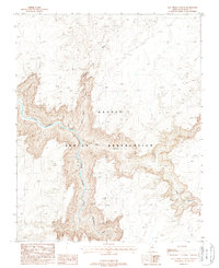
1988 Map of Salt Trail Canyon
USGS Topo · Published 1988About this map
Navajo Indian Reservation lands dominate this late-twentieth-century topographical survey, defined by the dramatic descent of the Little Colorado River. The river carves a deep Gorge through the plateau, joined by tributary drainages such as Big Canyon and Bekhatso Wash. The namesake Salt Trail provides a descent into the depths of Salt Trail Canyon, illustrating a historic route of access to the riverbed. This landscape is characterized by its isolation and topographical complexity, with a notable absence of permanent structures beyond scattered Corral sites. The intricate contour lines reveal the sheer vertical relief between the high desert mesa and the river floor, documenting the geographic character of this corner of Coconino County before modern development changes.
Find a feature on this map
8 named features on this map. Tap any name to fly to it.
Don’t see what you’re looking for? This feature index may not catch every label — zoom into the map to look around manually.
Map Details
Editions of this 1988 Salt Trail Canyon Map
This is the sole edition of this map. No revisions or reprints were ever made.
Other maps of this area

1886 · Echo Cliffs
USGS Topo · 1:250,000

1891 · Echo Cliffs
USGS Topo · 1:250,000

1907 · Vishnu
USGS Topo · 1:48,000

1954 · Shinumo Altar SE
USGS Topo · 1:24,000

1954 · Nankoweap
USGS Topo · 1:62,500

1954 · Shinumo Altar
USGS Topo · 1:62,500

1955 · Blue Spring NE
USGS Topo · 1:24,000
1955 · Blue Spring SE
USGS Topo · 1:24,000

1955 · Blue Spring
USGS Topo · 1:62,500

1956 · Marble Canyon
USGS Topo · 1:250,000