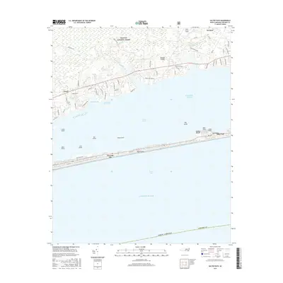
2016 Map of Salter Path
USGS Topo · Published 2016About this map
Bogue Banks stretches across the center of this coastal survey, separating the Atlantic Ocean and Onslow Bay from the sheltered waters of Bogue Sound. The barrier island is home to the established communities of Emerald Isle, Indian Beach, and Salter Path, where narrow residential grids contrast with the open marsh and small islands like Cat Island and Wood Island. To the north, the mainland transition begins at the Intracoastal Waterway, leading into the dense wetlands of the Croatan National Forest. The landscape here is defined by numerous tidal creeks, including West Prong Broad Creek and Prong Gales Cr, which drain the forest toward the sound. Further inland, the settlement of Newport and the community of Broad Creek sit among a network of rural roads such as Old Swansboro Rd, illustrating the intersection of timberlands and coastal maritime life in Carteret County.
Find a feature on this map
70 named features on this map. Tap any name to fly to it.
Don’t see what you’re looking for? This feature index may not catch every label — zoom into the map to look around manually.
Map Details
Editions of this 2016 Salter Path Map
This is the sole edition of this map. No revisions or reprints were ever made.
Other maps of this area

1942 · Maysville
USGS Topo · 1:62,500

1942 · Swansboro
USGS Topo · 1:62,500

1948 · Maysville
USGS Topo · 1:62,500

1948 · Swansboro
USGS Topo · 1:62,500

1949 · Newport
USGS Topo · 1:24,000

1949 · Salter Path
USGS Topo · 1:24,000

1949 · Mansfield
USGS Topo · 1:24,000

1949 · Masontown
USGS Topo · 1:24,000

1951 · Salter Path
USGS Topo · 1:24,000

1951 · Newport
USGS Topo · 1:24,000