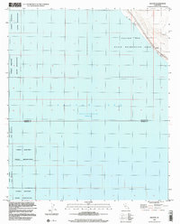
1998 Map of Salton
USGS Topo · Published 2003About this map
The Salton Sea dominates this landscape, recorded here at an elevation of 228 feet below sea level as of late 1992. Along its northeast shoreline, the Salton Sea State Recreation Area provides a structured boundary against the arid terrain of Riverside and Imperial counties. The map captures a transition point in the desert, where the Torres Martinez Indian Reservation covers significant portions of the shoreline and adjacent inland sections. Human infrastructure is concentrated near the coast, including a Landing Strip and named waterfront areas such as Betz Beach and Salton Beach. The presence of Route 111 running parallel to the water highlights the importance of this corridor for regional transit through the low-lying basin.
Find a feature on this map
9 named features on this map. Tap any name to fly to it.
Don’t see what you’re looking for? This feature index may not catch every label — zoom into the map to look around manually.
Map Details
Editions of this 1998 Salton Map
This is the sole edition of this map. No revisions or reprints were ever made.
Other maps of this area

1904 · Indio
USGS Topo · 1:125,000

1931 · Vallecito
USGS Topo · 1:125,000

1940 · Cottonwood Spring
USGS Topo · 1:62,500

1940 · Durmid
USGS Topo · 1:62,500

1941 · Coachella
USGS Topo · 1:62,500

1942 · Agua Dulce
USGS Topo · 1:62,500

1943 · Vallecito
USGS Topo · 1:125,000

1943 · Coachella
USGS Topo · 1:62,500

1944 · Agua Dulce
USGS Topo · 1:62,500

1944 · Cottonwood Spring
USGS Topo · 1:62,500