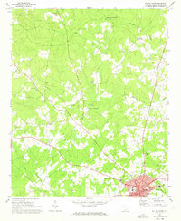
1971 Map of Saluda North
USGS Topo · Published 1973About this map
The town of Saluda serves as the hub of this rural landscape, situated just south of the convergence of numerous creek branches. In the early 1970s, the community structure is defined by its churches and schools, such as Mt Pleasant Sch and Pleasant Hill Ch. The northern portion of the region is characterized by named intersections like Chapmans Crossroads and Colemans Crossroads, which reflect a historical settlement pattern based on key transit points. Waterways like Big Creek, Dry Creek, and Burnets Creek carve through the terrain, while the Saluda Lookout Tower and a local Armory stand as prominent landmarks near the town center. Genealogists will find particular value in the numerous church-adjacent burial grounds and the larger Travis Park Cem near the Courthouse.
Find a feature on this map
39 named features on this map. Tap any name to fly to it.
Don’t see what you’re looking for? This feature index may not catch every label — zoom into the map to look around manually.
Map Details
Editions of this 1971 Saluda North Map
This is the sole edition of this map. No revisions or reprints were ever made.
Other maps of this area

1941 · Spartanburg
USGS Topo · 1:250,000

1953 · Spartanburg
USGS Topo · 1:250,000

1954 · Augusta
USGS Topo · 1:250,000

1957 · Augusta
USGS Topo · 1:250,000

1958 · Augusta
USGS Topo · 1:250,000

1960 · Spartanburg
USGS Topo · 1:250,000

1961 · Augusta
USGS Topo · 1:250,000

1962 · Augusta
USGS Topo · 1:250,000

1963 · Spartanburg
USGS Topo · 1:250,000

1964 · Spartanburg
USGS Topo · 1:250,000