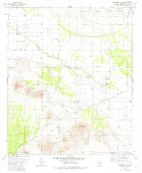
1981 Map of Samaniego Hills
USGS Topo · Published 1981About this map
The Sasco Ruins and nearby Sasco Cem stand as significant markers of Arizona's industrial past, representing a former copper smelting community situated at the base of the Samaniego Hills. This 1981 record captures the remnants of that era, showing the Old Railroad Grade that once connected these desert outposts and the Sasco Road cutting through the landscape. The arid terrain is further defined by the Santa Cruz River and the engineered path of the Greene Canal in the north.
Find a feature on this map
22 named features on this map. Tap any name to fly to it.
Don’t see what you’re looking for? This feature index may not catch every label — zoom into the map to look around manually.
Map Details
Editions of this 1981 Samaniego Hills Map
3 editions found
Other maps of this area

1934 · Tucson Mountains
USGS Topo · 1:125,000

1934 · Silver Bell
USGS Topo · 1:125,000

1934 · Newman Peak
USGS Topo · 1:125,000

1947 · Red Rock
USGS Topo · 1:62,500

1947 · Eloy
USGS Topo · 1:62,500

1948 · Eloy
USGS Topo · 1:62,500

1956 · Tucson
USGS Topo · 1:250,000

1958 · Tucson
USGS Topo · 1:250,000

1959 · Tucson
USGS Topo · 1:250,000

1959 · Vaca Hills
USGS Topo · 1:62,500