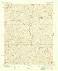
1940 Map of Sams Gap
USGS Topo · Published 1940About this map
Sams Gap serves as the central crossing point for the Appalachian Trail along the high boundary between North Carolina and Tennessee in 1940. This survey, conducted just before the peak of mid-century infrastructure changes, documents a landscape defined by isolated mountain communities such as Little Creek and Faust. The area is densely patterned with family-named landmarks and local institutions, including the Rice Creek Sch and the Rice Bend Ch, reflecting a deeply rooted rural society.
Find a feature on this map
112 named features on this map. Tap any name to fly to it.
Don’t see what you’re looking for? This feature index may not catch every label — zoom into the map to look around manually.
Map Details
Editions of this 1940 Sams Gap Map
This is the sole edition of this map. No revisions or reprints were ever made.
Other maps of this area

1891 · Roan Mountain
USGS Topo · 1:125,000

1892 · Greeneville
USGS Topo · 1:125,000

1894 · Asheville
USGS Topo · 1:125,000

1894 · Roan Mountain
USGS Topo · 1:125,000

1896 · Greeneville
USGS Topo · 1:125,000

1900 · Mount Mitchell
USGS Topo · 1:125,000

1901 · Asheville
USGS Topo · 1:125,000

1902 · Mount Mitchell
USGS Topo · 1:125,000

1904 · Roan Mountain
USGS Topo · 1:125,000

1904 · Greeneville
USGS Topo · 1:125,000