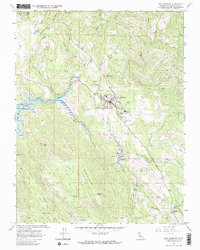
1962 Map of San Andreas
USGS Topo · Published 1964About this map
San Andreas serves as the focal point of this 1962 survey, situated at the confluence of the North Fork and South Fork Calaveras River. The landscape reveals a transition from the established gold-mining era toward modern industrial and civic development, marked by the presence of a large Cement Plant and quarries near Kentucky House. Local history is deeply etched into the terrain through numerous family-named claims such as the Cassinelli Mine and Lloyd Mine, alongside the Pioneer Cem which preserves the memory of early settlers. The mapping captures a significant hydrological shift as the Calaveras Reservoir is shown with its spillway elevation, while a dashed blue pattern indicates areas subject to controlled inundation from the New Hogan Reservoir. This document provides a clear view of the mid-century infrastructure supporting the county seat, from the Mark Twain Hospital to the Calaveras County Airport.
Find a feature on this map
43 named features on this map. Tap any name to fly to it.
Don’t see what you’re looking for? This feature index may not catch every label — zoom into the map to look around manually.
Map Details
Editions of this 1962 San Andreas Map
3 editions found
Other maps of this area

1889 · Jackson
USGS Topo · 1:125,000

1892 · Jackson
USGS Topo · 1:125,000

1897 · Jackson
USGS Topo · 1:125,000

1902 · Jackson
USGS Topo · 1:125,000

1941 · Sutter Creek
USGS Topo · 1:62,500

1944 · Valley Springs
USGS Topo · 1:62,500

1944 · Sutter Creek
USGS Topo · 1:62,500

1945 · San Andreas
USGS Topo · 1:62,500

1947 · San Andreas
USGS Topo · 1:62,500

1947 · Sacramento
USGS Topo · 1:250,000
Featured Places
- Mountain Ranch Subdivision, CA
- Fourth Crossing, CA
- San Andreas, CA
- Oak Park Estates, CA
- Toyanza Subdivision, CA