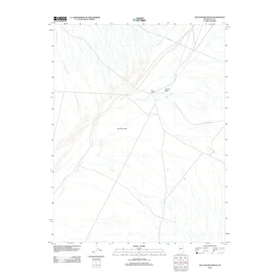
2012 Map of San Antonio Ranch
USGS Topo · Published 2012About this map
San Antonio Smelting Works stands as a primary industrial landmark in this corner of the Big Smoky Valley, reflecting the mineral processing heritage of Nye County. The landscape is defined by the ephemeral drainage patterns of Peavine Creek and Cottonwood Creek as they descend toward the valley floor. Settled activity is centered at San Antonio Ranch, situated near the reliable waters of Indian Springs. The road network provides evidence of historical transit and industrial access, including the Fremont Rte and Anaconda Rd, which connect the ranch and smelting site to the broader Nevada interior. This survey documents the intersection of ranching life and mining infrastructure within the arid topography of the Great Basin during the early twenty-first century.
Find a feature on this map
10 named features on this map. Tap any name to fly to it.
Don’t see what you’re looking for? This feature index may not catch every label — zoom into the map to look around manually.
Map Details
Editions of this 2012 San Antonio Ranch Map
This is the sole edition of this map. No revisions or reprints were ever made.
Other maps of this area

1907 · Tonopah
USGS Topo · 1:250,000

1908 · Tonopah
USGS Topo · 1:250,000

1956 · Tonopah
USGS Topo · 1:250,000

1959 · Tonopah
USGS Topo · 1:250,000

1962 · Tonopah
USGS Topo · 1:250,000

1963 · Baxter Spring
USGS Topo · 1:62,500

1964 · San Antonio Ranch
USGS Topo · 1:62,500

1971 · Seyler Peak
USGS Topo · 1:24,000

1980 · Secret Basin
USGS Topo · 1:24,000
1980 · Peavine Ranch
USGS Topo · 1:24,000