
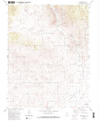
2014 Map of San Antonio Ranch
USGS Topo · Published 2014About this map
San Antonio Ranch serves as a lone point of settlement within the expansive Big Smoky Valley in Nye County. This high-desert landscape is defined by its intermittent water sources and historic transit lines. The Fremont Route traverses the terrain, marking a corridor of historical significance that follows the natural drainage of Peavine Cr. The presence of Indian Springs highlights the critical role of reliable water in this arid environment, providing a focal point for activity in an otherwise sparsely populated area. Modern infrastructure is represented by Anaconda Rd, which cuts across the valley floor. The map details the complex drainage patterns of ephemeral streams like Cottonwood Cr, illustrating how the geography dictated the placement of early ranching outposts and travel ways.
Find a feature on this map
11 named features on this map. Tap any name to fly to it.
Don’t see what you’re looking for? This feature index may not catch every label — zoom into the map to look around manually.
Map Details
Editions of this 2014 San Antonio Ranch Map
This is the sole edition of this map. No revisions or reprints were ever made.
Other maps of this area

1907 · Tonopah
USGS Topo · 1:250,000

1908 · Tonopah
USGS Topo · 1:250,000

1956 · Tonopah
USGS Topo · 1:250,000

1959 · Tonopah
USGS Topo · 1:250,000

1962 · Tonopah
USGS Topo · 1:250,000

1963 · Baxter Spring
USGS Topo · 1:62,500

1964 · San Antonio Ranch
USGS Topo · 1:62,500

1971 · Seyler Peak
USGS Topo · 1:24,000

1980 · Secret Basin
USGS Topo · 1:24,000
1980 · Peavine Ranch
USGS Topo · 1:24,000