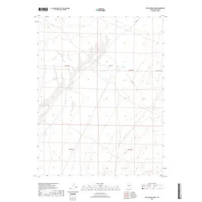
2018 Map of San Antonio Ranch
USGS Topo · Published 2018About this map
San Antonio Ranch serves as a lone outpost in this 2018 survey of Nye County, located where the desert plains meet the eastern edge of the Big Smoky Valley. The landscape is defined by its arid hydrology, featuring the winding ephemeral paths of Peavine Creek and Cottonwood Creek as they drain toward the valley floor. A critical water source, Indian Springs, is situated east of the ranch, providing a rare point of reliability in this high-desert environment. Transportation through this remote stretch of Nevada relies on established tracks like Anaconda Rd and the Fremont Rte, which cut across the alluvial fans. This map is an essential reference for understanding contemporary land use and water management in a region where historic ranching footprints still dictate the local geography.
Find a feature on this map
14 named features on this map. Tap any name to fly to it.
Don’t see what you’re looking for? This feature index may not catch every label — zoom into the map to look around manually.
Map Details
Editions of this 2018 San Antonio Ranch Map
This is the sole edition of this map. No revisions or reprints were ever made.
Other maps of this area

1907 · Tonopah
USGS Topo · 1:250,000

1908 · Tonopah
USGS Topo · 1:250,000

1956 · Tonopah
USGS Topo · 1:250,000

1959 · Tonopah
USGS Topo · 1:250,000

1962 · Tonopah
USGS Topo · 1:250,000

1963 · Baxter Spring
USGS Topo · 1:62,500

1964 · San Antonio Ranch
USGS Topo · 1:62,500

1971 · Seyler Peak
USGS Topo · 1:24,000

1980 · Secret Basin
USGS Topo · 1:24,000
1980 · Peavine Ranch
USGS Topo · 1:24,000