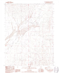
1987 Map of San Antonio Ranch
USGS Topo · Published 1987About this map
Big Smoky Valley dominates this high-desert landscape in Nye County, revealing a remote region defined by its scarce water resources and ranching outposts in the mid-1980s. The settlement of San Antonio Ranch serves as a primary landmark, accompanied nearby by the label for San Antonio and a critical San Antonio Well. This area illustrates the infrastructure required for desert survival and industry, including an Aqueduct and a prominent Transmission Line cutting across the valley floor. To the west, the drainage of Peavine Creek flows toward the center of the basin, where active geological processes are evident in the sprawling Sand Dunes. Evidence of mineral exploration and land use is found in scattered Prospects and a Borrow Pit, while multiple Spring and Wells locations pinpoint the few reliable water sources available in this arid stretch of the Great Basin.
Find a feature on this map
14 named features on this map. Tap any name to fly to it.
Don’t see what you’re looking for? This feature index may not catch every label — zoom into the map to look around manually.
Map Details
Editions of this 1987 San Antonio Ranch Map
This is the sole edition of this map. No revisions or reprints were ever made.
Other maps of this area

1907 · Tonopah
USGS Topo · 1:250,000

1908 · Tonopah
USGS Topo · 1:250,000

1956 · Tonopah
USGS Topo · 1:250,000

1959 · Tonopah
USGS Topo · 1:250,000

1962 · Tonopah
USGS Topo · 1:250,000

1963 · Baxter Spring
USGS Topo · 1:62,500

1964 · San Antonio Ranch
USGS Topo · 1:62,500

1971 · Seyler Peak
USGS Topo · 1:24,000

1980 · Secret Basin
USGS Topo · 1:24,000
1980 · Peavine Ranch
USGS Topo · 1:24,000