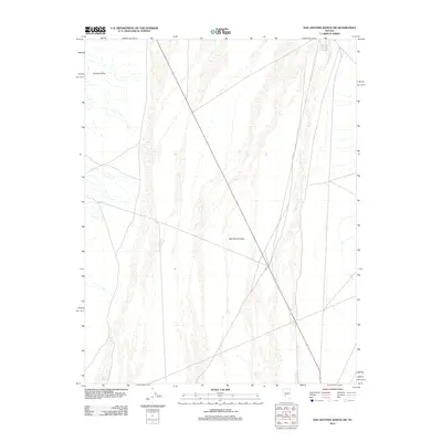
2012 Map of San Antonio Ranch SW
USGS Topo · Published 2012About this map
Big Smoky Valley dominates this 2012 topographic study of the Nye County landscape, where the wide desert basin meets the rising slopes of the Royston Hills. This map documents a high-desert environment defined by seasonal drainage patterns and sparse infrastructure. Hydrographic features such as Peavine Creek and Ione Wash are mapped as they traverse the valley floor, indicating the flow of water during infrequent rain events. The transportation network is minimal, consisting of a few established routes like Peavine Rd that provide access through this expansive terrain. This survey is a precise record of the Great Basin’s physical geography, useful for understanding land use and natural resources in a region where the vastness of the valley is punctuated only by occasional hills and intermittent streambeds.
Find a feature on this map
5 named features on this map. Tap any name to fly to it.
Don’t see what you’re looking for? This feature index may not catch every label — zoom into the map to look around manually.
Map Details
Editions of this 2012 San Antonio Ranch SW Map
This is the sole edition of this map. No revisions or reprints were ever made.
Other maps of this area

1907 · Tonopah
USGS Topo · 1:250,000

1908 · Tonopah
USGS Topo · 1:250,000

1956 · Tonopah
USGS Topo · 1:250,000

1959 · Tonopah
USGS Topo · 1:250,000

1961 · Lone Mtn
USGS Topo · 1:62,500

1962 · Tonopah
USGS Topo · 1:250,000

1964 · San Antonio Ranch
USGS Topo · 1:62,500

1968 · Crow Springs
USGS Topo · 1:24,000
1980 · Outlaw Springs SE
USGS Topo · 1:24,000
1980 · Outlaw Springs NE
USGS Topo · 1:24,000