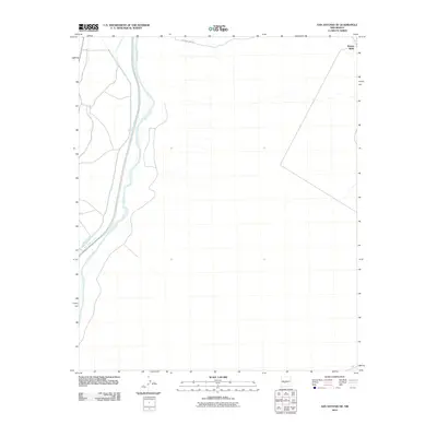
2010 Map of San Antonio SE
USGS Topo · Published 2010About this map
The Rio Grande corridor in central New Mexico is defined by its complex irrigation network, as seen in this 2010 survey of the area southeast of San Antonio. Water management remains central to the landscape, with the San Antonio Ditch and Elmendorf Ditch running parallel to the river's eastern bank. These features reflect the long-standing tradition of acequias and shared water rights essential for agriculture in this arid region. On the eastern edge of the quadrangle, Kinney Wells stands as a lonely landmark near the desert hills, while Guadalajara Rd provides one of the few improved access points across the northern plains. This map captures the intersection of historical riparian infrastructure and the open terrain of Socorro County.
Find a feature on this map
5 named features on this map. Tap any name to fly to it.
Don’t see what you’re looking for? This feature index may not catch every label — zoom into the map to look around manually.
Map Details
Editions of this 2010 San Antonio SE Map
This is the sole edition of this map. No revisions or reprints were ever made.
Other maps of this area

1948 · Carthage
USGS Topo · 1:62,500

1948 · Granjean Well
USGS Topo · 1:62,500

1948 · San Antonio
USGS Topo · 1:62,500

1948 · Val Verde
USGS Topo · 1:62,500

1954 · Tularosa
USGS Topo · 1:250,000

1958 · Tularosa
USGS Topo · 1:250,000

1981 · Granjean Well
USGS Topo · 1:24,000
1981 · San Antonio
USGS Topo · 1:24,000
1981 · Indian Well Wilderness
USGS Topo · 1:24,000
1981 · Canon Agua Buena
USGS Topo · 1:24,000