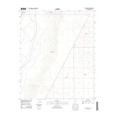
2013 Map of San Antonio SE
USGS Topo · Published 2013About this map
The Rio Grande corridor in Socorro County is defined here by its complex irrigation infrastructure, including the Elmendorf Ditch and San Antonio Ditch. These waterways parallel the river, supporting the small settlement of San Antonito at the edge of a transitioning landscape. East of the river valley, the terrain shifts abruptly into the arid basin of the Jornada del Muerto, where water management is limited to isolated features like Table Mountain Tank and Fite Tank. The juxtaposition of the verdant river valley and the desert interior illustrates the importance of water rights and land use in this part of New Mexico, while Guadalajara Rd provides a singular point of access into the eastern flats.
Find a feature on this map
12 named features on this map. Tap any name to fly to it.
Don’t see what you’re looking for? This feature index may not catch every label — zoom into the map to look around manually.
Map Details
Editions of this 2013 San Antonio SE Map
This is the sole edition of this map. No revisions or reprints were ever made.
Other maps of this area

1948 · Carthage
USGS Topo · 1:62,500

1948 · Granjean Well
USGS Topo · 1:62,500

1948 · San Antonio
USGS Topo · 1:62,500

1948 · Val Verde
USGS Topo · 1:62,500

1954 · Tularosa
USGS Topo · 1:250,000

1958 · Tularosa
USGS Topo · 1:250,000

1981 · Granjean Well
USGS Topo · 1:24,000
1981 · San Antonio
USGS Topo · 1:24,000
1981 · Indian Well Wilderness
USGS Topo · 1:24,000
1981 · Canon Agua Buena
USGS Topo · 1:24,000