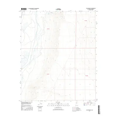
2017 Map of San Antonio SE
USGS Topo · Published 2017About this map
The Rio Grande defines the western edge of this Socorro County landscape, flanked by a network of historic irrigation structures including the San Antonio Ditch and Elmendorf Ditch. These waterways represent the vital lifelines of the Rio Grande Valley, supporting agricultural activity in an otherwise arid environment. Moving east from the river, the terrain rises toward rugged uplands marked by essential water catchment features such as Table Mountain Tank and Fite Tank. The presence of Fite Ranch Rd in the north indicates the importance of ranching in this high-desert region. The map provides a detailed view of the cadastral grid, showing the township and range lines of t5s r1e, t5s r2e, and the sections to the south, which remain fundamental for property researchers and land historians in New Mexico.
Find a feature on this map
10 named features on this map. Tap any name to fly to it.
Don’t see what you’re looking for? This feature index may not catch every label — zoom into the map to look around manually.
Map Details
Editions of this 2017 San Antonio SE Map
This is the sole edition of this map. No revisions or reprints were ever made.
Other maps of this area

1948 · Carthage
USGS Topo · 1:62,500

1948 · Granjean Well
USGS Topo · 1:62,500

1948 · San Antonio
USGS Topo · 1:62,500

1948 · Val Verde
USGS Topo · 1:62,500

1954 · Tularosa
USGS Topo · 1:250,000

1958 · Tularosa
USGS Topo · 1:250,000

1981 · Granjean Well
USGS Topo · 1:24,000
1981 · San Antonio
USGS Topo · 1:24,000
1981 · Indian Well Wilderness
USGS Topo · 1:24,000
1981 · Canon Agua Buena
USGS Topo · 1:24,000