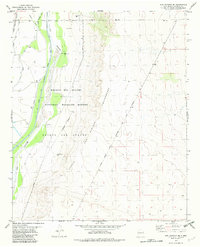
1982 Map of San Antonio SE
USGS Topo · Published 1982About this map
Bosque Del Apache National Wildlife Refuge dominates this section of the Middle Rio Grande Valley, showcasing a complex irrigation and water management system developed by the late twentieth century. The Rio Grande is flanked by an intricate network of man-made waterways, including the San Antonio Riverside Drain, Elmendorf Ditch, and the Conveyance Channel, reflecting the region's critical reliance on engineered water distribution for conservation and agriculture.
Find a feature on this map
21 named features on this map. Tap any name to fly to it.
Don’t see what you’re looking for? This feature index may not catch every label — zoom into the map to look around manually.
Map Details
Editions of this 1982 San Antonio SE Map
This is the sole edition of this map. No revisions or reprints were ever made.
Other maps of this area

1948 · Carthage
USGS Topo · 1:62,500

1948 · Granjean Well
USGS Topo · 1:62,500

1948 · San Antonio
USGS Topo · 1:62,500

1948 · Val Verde
USGS Topo · 1:62,500

1954 · Tularosa
USGS Topo · 1:250,000

1958 · Tularosa
USGS Topo · 1:250,000

1981 · Granjean Well
USGS Topo · 1:24,000
1981 · San Antonio
USGS Topo · 1:24,000
1981 · Indian Well Wilderness
USGS Topo · 1:24,000
1981 · Canon Agua Buena
USGS Topo · 1:24,000