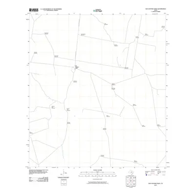
2010 Map of San Antonio Viejo
USGS Topo · Published 2010About this map
San Antonio Viejo serves as the central focal point in this 2010 depiction of the South Texas rangeland. The landscape is defined by its water infrastructure, which is essential for cattle ranching in the semi-arid Brush Country. A dense network of named landmarks, including Esperanza Windmill, Lobo Blanco Windmill, and San Pedro Windmill, demonstrates how the land has been managed and partitioned over generations. Transport through this area relies on a handful of thoroughfares such as Gallagher Ranch Rd, which connects the various ranching stations. The few natural water features, like Remadura de Charco Largo Creek, provide a glimpse into the local hydrology that supports this environment. This map is particularly useful for those researching ranching history or family landholdings in Jim Hogg County, showing the specific location of named windmills like Rancho Viejo Windmill and Cisterna Alta Windmill that often served as local navigation points.
Find a feature on this map
27 named features on this map. Tap any name to fly to it.
Don’t see what you’re looking for? This feature index may not catch every label — zoom into the map to look around manually.
Map Details
Editions of this 2010 San Antonio Viejo Map
This is the sole edition of this map. No revisions or reprints were ever made.
Other maps of this area

1938 · Agua Nueva
USGS Topo · 1:62,500

1938 · Cuevitas
USGS Topo · 1:62,500

1939 · Randado
USGS Topo · 1:62,500

1940 · Randado
USGS Topo · 1:62,500

1949 · Mc Allen
USGS Topo · 1:250,000

1954 · McAllen
USGS Topo · 1:250,000

1956 · Laredo
USGS Topo · 1:250,000

1957 · Mc Allen
USGS Topo · 1:250,000

1962 · McAllen
USGS Topo · 1:250,000
1972 · San Pablo Ranch
USGS Topo · 1:24,000