
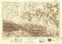
1953 Map of San Bernardino
USGS Topo · Published 1953About this map
The San Bernardino National Forest dominates the center of this mid-century landscape, separating the developing urban corridor from the high Mojave Desert. This 1953 perspective shows the San Bernardino Valley as a burgeoning suburban and industrial hub, with towns like San Bernardino, Redlands, and Ontario interconnected by a dense network of transit, including the Pacific Electric RR and Atchison Topeka and Santa Fe RR. Beyond the peak of San Gorgonio Mountain, the map transitions into the arid basins of the Mojave Valley, where remote sites like Old Woman Springs and the Camp Rock Mine highlight the era's desert activity. Strategic military installations including Edwards Air Force Base and George Air Force Base anchor the northern reaches, while the southeastern corner reveals the early boundaries of Joshua Tree National Monument.
Find a feature on this map
175 named features on this map. Tap any name to fly to it.
Don’t see what you’re looking for? This feature index may not catch every label — zoom into the map to look around manually.
Map Details
Editions of this 1953 San Bernardino Map
2 editions found
Other maps of this area

1894 · Los Angeles
USGS Topo · 1:62,500

1894 · Pomona
USGS Topo · 1:62,500

1896 · Pasadena
USGS Topo · 1:62,500

1896 · Anaheim
USGS Topo · 1:62,500

1896 · San Bernardino
USGS Topo · 1:62,500

1896 · Downey
USGS Topo · 1:62,500

1897 · Pomona
USGS Topo · 1:62,500

1897 · Cucamonga
USGS Topo · 1:62,500

1898 · Pomona
USGS Topo · 1:62,500

1898 · San Bernardino
USGS Topo · 1:62,500