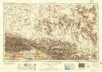
1953 Map of San Bernardino
USGS Topo · Published 1954About this map
The sprawling mid-century landscape of the Mojave Desert and the San Bernardino Mountains reveals a period of intense military and suburban expansion. Established defense centers like Edwards Air Force Base and Norton AFB anchor the high desert and valley, while the residential footprints of San Bernardino and Redlands begin to coalesce at the base of the San Bernardino National Forest. This 1953 compilation, based on data from the Army Map Service and USGS, illustrates the transit-oriented development of the era, following the Atchison Topeka and Santa Fe RR and historic U.S. 66. In the arid interior, the map preserves the locations of early resource extraction at the Camp Rock Mine and Sunshine Mine, alongside the vast dry playas of Lucerne Lake and Rogers Lake. This record captures the transition from a mining and ranching economy to a major strategic and residential corridor.
Find a feature on this map
150 named features on this map. Tap any name to fly to it.
Don’t see what you’re looking for? This feature index may not catch every label — zoom into the map to look around manually.
Map Details
Editions of this 1953 San Bernardino Map
2 editions found

Other maps of this area

1894 · Los Angeles
USGS Topo · 1:62,500

1894 · Pomona
USGS Topo · 1:62,500

1896 · Pasadena
USGS Topo · 1:62,500

1896 · Anaheim
USGS Topo · 1:62,500

1896 · San Bernardino
USGS Topo · 1:62,500

1896 · Downey
USGS Topo · 1:62,500

1897 · Pomona
USGS Topo · 1:62,500

1897 · Cucamonga
USGS Topo · 1:62,500

1898 · Pomona
USGS Topo · 1:62,500

1898 · San Bernardino
USGS Topo · 1:62,500