
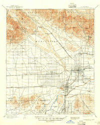
1958 Map of San Bernardino
USGS Topo · Published 1975About this map
The San Bernardino Mountains and the northern sprawl of the Los Angeles basin dominate this late-1950s landscape, illustrating a period of rapid suburban and military expansion. From the dense residential grids of San Bernardino and Ontario, the map tracks the development of the Inland Empire along major transit corridors like Interstate 10. The presence of Norton AFB, George Air Force Base, and the Marine Corps Base at Twentynine Palms underscores the region's strategic importance during the Cold War era.
Find a feature on this map
221 named features on this map. Tap any name to fly to it.
Don’t see what you’re looking for? This feature index may not catch every label — zoom into the map to look around manually.
Map Details
Editions of this 1958 San Bernardino Map
This is the sole edition of this map. No revisions or reprints were ever made.
Historical Maps of Ontario Ranch Through Time
12 maps found

1896 San Bernardino
San Bernardino County, CA

1898 San Bernardino
San Bernardino County, CA
1901 San Bernardino
San Bernardino County, CA

1942 San Bernardino
San Bernardino County, CA
1953 San Bernardino
San Bernardino County, CA
1954 San Bernardino
San Bernardino County, CA

1956 San Bernardino
San Bernardino County, CA

1957 San Bernardino
San Bernardino County, CA
1958 San Bernardino
San Bernardino County, CA

1959 San Bernardino
San Bernardino County, CA

1966 San Bernardino
San Bernardino County, CA

1982 San Bernardino
San Bernardino County, CA