
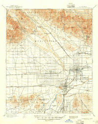
1959 Map of San Bernardino
USGS Topo · Published 1959About this map
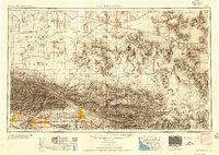
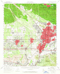
The San Bernardino Mountains and the arid expanse of the Mojave Desert dominate this late 1950s landscape, illustrating a period of significant military and suburban expansion in Southern California. Strategic installations such as Edwards Air Force Base and George Air Force Base anchor the high desert, while the emerging communities of Victorville and Barstow follow the path of the Mojave River. To the south, the rapidly growing urban corridor stretching from Pomona and Ontario to San Bernardino and Redlands is interconnected by a dense network of transit, including the Pacific Electric Railway and the Atchison Topeka and Santa Fe Railway. This survey also highlights the recreational and conservation landscape of the era, from the alpine settlements at Big Bear Lake and Lake Arrowhead to the sprawling, undeveloped reaches of Joshua Tree National Monument and the San Gorgonio Wilderness.
Find a feature on this map
272 named features on this map. Tap any name to fly to it.
Don’t see what you’re looking for? This feature index may not catch every label — zoom into the map to look around manually.
Map Details
Editions of this 1959 San Bernardino Map
This is the sole edition of this map. No revisions or reprints were ever made.
Historical Maps of Ontario Ranch Through Time
12 maps found

1896 San Bernardino
San Bernardino County, CA

1898 San Bernardino
San Bernardino County, CA
1901 San Bernardino
San Bernardino County, CA

1942 San Bernardino
San Bernardino County, CA
1953 San Bernardino
San Bernardino County, CA
1954 San Bernardino
San Bernardino County, CA

1956 San Bernardino
San Bernardino County, CA

1957 San Bernardino
San Bernardino County, CA

1958 San Bernardino
San Bernardino County, CA
1959 San Bernardino
San Bernardino County, CA

1966 San Bernardino
San Bernardino County, CA

1982 San Bernardino
San Bernardino County, CA