
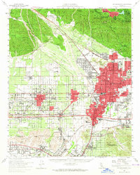
1966 Map of San Bernardino
USGS Topo · Published 1966About this map
San Bernardino and the booming San Bernardino Valley anchor this mid-century look at the collision of Southern California's citrus-belt heritage and its expanding Cold War defense infrastructure. The southern edge of the map shows a dense corridor of settlements including Fontana, Rialto, and Redlands, contrasted sharply with the high elevations of the San Bernardino Mountains and the summit of San Gorgonio Mountain.
Find a feature on this map
153 named features on this map. Tap any name to fly to it.
Don’t see what you’re looking for? This feature index may not catch every label — zoom into the map to look around manually.
Map Details
Editions of this 1966 San Bernardino Map
This is the sole edition of this map. No revisions or reprints were ever made.
Historical Maps of Ontario Ranch Through Time
12 maps found

1896 San Bernardino
San Bernardino County, CA

1898 San Bernardino
San Bernardino County, CA
1901 San Bernardino
San Bernardino County, CA

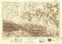
1942 San Bernardino
San Bernardino County, CA
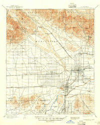
1953 San Bernardino
San Bernardino County, CA
1954 San Bernardino
San Bernardino County, CA

1956 San Bernardino
San Bernardino County, CA

1957 San Bernardino
San Bernardino County, CA

1958 San Bernardino
San Bernardino County, CA

1959 San Bernardino
San Bernardino County, CA
1966 San Bernardino
San Bernardino County, CA

1982 San Bernardino
San Bernardino County, CA