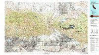
1982 Map of San Bernardino
USGS Topo · Published 1983About this map
Norton Air Force Base and the expansive urban grid of San Bernardino anchor the eastern side of this early 1980s survey, illustrating the intense development at the foot of the San Bernardino Mountains. The map traces a massive logistics and transit corridor where the Southern Pacific, Union Pacific, and Atchison Topeka and Santa Fe railroads converge to navigate the Cajon Pass. This geographic bottleneck between the San Gabriel Mountains and the eastern ranges serves as the primary gateway for goods moving from the Los Angeles basin toward Hesperia and the high desert.
Find a feature on this map
169 named features on this map. Tap any name to fly to it.
Don’t see what you’re looking for? This feature index may not catch every label — zoom into the map to look around manually.
Map Details
Editions of this 1982 San Bernardino Map
This is the sole edition of this map. No revisions or reprints were ever made.
Other maps of this area

1894 · Los Angeles
USGS Topo · 1:62,500

1894 · Pomona
USGS Topo · 1:62,500

1896 · Pasadena
USGS Topo · 1:62,500

1896 · Anaheim
USGS Topo · 1:62,500

1896 · San Bernardino
USGS Topo · 1:62,500

1896 · Downey
USGS Topo · 1:62,500

1897 · Pomona
USGS Topo · 1:62,500

1897 · Cucamonga
USGS Topo · 1:62,500

1898 · Pomona
USGS Topo · 1:62,500

1898 · San Bernardino
USGS Topo · 1:62,500