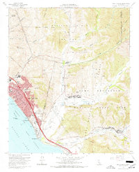
1968 Map of San Clemente
USGS Topo · Published 1970About this map
San Clemente sits at a geographic and historical transition point in the late 1960s, where residential growth meets the northern edge of the Camp Pendleton Marine Corps Base. The town is defined by its coastal orientation, featuring the San Clemente Pier and San Clemente State Beach, while the inland canyons like Cañada Deshecha and Gabino Canyon suggest the open ranching heritage of the Mission Viejo and La Paz grants. This period captures the town just as the San Diego Freeway and the Atchison Topeka and Santa Fe Ry solidified its role as a coastal corridor. Local education and faith centers, such as Our Lady of Fatima Sch and San Luis Rey Church, are firmly established. To the east, the landscape shifts toward military training grounds and firing ranges, punctuated by the Cristianitos Historic Site along Cristianitos Creek.
Find a feature on this map
45 named features on this map. Tap any name to fly to it.
Don’t see what you’re looking for? This feature index may not catch every label — zoom into the map to look around manually.
Map Details
Editions of this 1968 San Clemente Map
3 editions found
Other maps of this area

1901 · Southern California Sheet No. 1
USGS Topo · 1:250,000

1901 · Elsinore
USGS Topo · 1:125,000

1901 · San Luis Rey
USGS Topo · 1:125,000

1902 · Capistrano
USGS Topo · 1:125,000

1902 · Corona
USGS Topo · 1:125,000

1904 · Southern California Sheet No. 2
USGS Topo · 1:250,000

1904 · Southern California Sheet No. 1
USGS Topo · 1:250,000

1906 · Capistrano
USGS Topo · 1:125,000

1941 · Margarita Peak
USGS Topo · 1:62,500

1942 · Lake Elsinore
USGS Topo · 1:62,500
Featured Places
- San Clemente, CA
- San Juan Capistrano, CA
- Marine Corps Base Camp Pendleton, CA
- San Onofre, Marine Corps Base Camp Pendleton
- San Diego County, CA