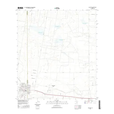
2016 Map of San Diego
USGS Topo · Published 2016About this map
The county seat of San Diego straddles the boundary between Duval Co and Jim Wells Co in South Texas. The settlement’s traditional grid is well-defined, featuring streets like N Trevino St, N Benavides St, and W Nickerson Ave that reflect the region’s deep cultural heritage. Development extends eastward to Loma Linda East, positioned just north of the seasonal channel of San Diego Cr.
Find a feature on this map
69 named features on this map. Tap any name to fly to it.
Don’t see what you’re looking for? This feature index may not catch every label — zoom into the map to look around manually.
Map Details
Editions of this 2016 San Diego Map
This is the sole edition of this map. No revisions or reprints were ever made.
Other maps of this area

1917 · Ben Bolt
USGS Topo · 1:62,500

1920 · San Diego
USGS Topo · 1:62,500

1956 · Benavides
USGS Topo · 1:62,500

1956 · Rosita Ranch
USGS Topo · 1:62,500

1956 · Laredo
USGS Topo · 1:250,000

1963 · San Diego NE
USGS Topo · 1:24,000

1963 · San Diego
USGS Topo · 1:24,000
1963 · Shaeffer Ranch
USGS Topo · 1:24,000
1963 · Alice North
USGS Topo · 1:24,000

1963 · Ben Bolt NW
USGS Topo · 1:24,000