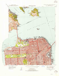
1947 Map of San Francisco North
USGS Topo · Published 1955About this map
The northern tip of the San Francisco peninsula appears in transition following the war, showcasing the dense urban grid of Nob Hill and the Ferry Building alongside expansive military footprints. The Presidio Military Reservation and Fort Mason Military Res dominate the northern shoreline, while the newly completed Golden Gate Bridge anchors the western entrance to the harbor. Across the Golden Gate, the mariner's landscape includes Alcatraz Island and Angel Island, with the distinct contours of Sausalito and Belvedere rising from Richardson Bay. In the heart of the city, local life centers on landmarks like Seals Stadium and Kezar Stadium, plus numerous educational institutions from Lowell HS to Gompers Trade Sch. The map preserves the waterfront's industrial character before modern redevelopment, highlighting China Basin and the Richmond-San Francisco Freight Ferry route.
Find a feature on this map
124 named features on this map. Tap any name to fly to it.
Don’t see what you’re looking for? This feature index may not catch every label — zoom into the map to look around manually.
Map Details
Editions of this 1947 San Francisco North Map
This is the sole edition of this map. No revisions or reprints were ever made.
Other maps of this area

1892 · San Mateo
USGS Topo · 1:62,500

1895 · San Francisco
USGS Topo · 1:62,500

1896 · San Mateo
USGS Topo · 1:62,500

1897 · Tamalpais
USGS Topo · 1:62,500

1899 · San Francisco
USGS Topo · 1:62,500

1899 · San Mateo
USGS Topo · 1:62,500

1915 · San Mateo
USGS Topo · 1:62,500

1915 · San Francisco
USGS Topo · 1:62,500

1939 · San Mateo
USGS Topo · 1:62,500

1941 · Tamalpais
USGS Topo · 1:62,500