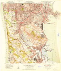
1950 Map of San Francisco South
USGS Topo · Published 1950About this map
San Francisco and its southern neighboring communities in San Mateo County undergo significant post-war expansion on this 1950 edition. The landscape is defined by the massive cluster of memorial parks in Colma, including Holy Cross Cemetery and Hills of Eternity Cem, which creates a unique green belt between the residential grids of Daly City and South San Francisco. To the east, the shoreline of San Francisco Bay shows the early footprint of the San Francisco International Airport and industrial landmarks like the Livestock Exposition Bldg near Visitacion Pt. Significant geological features such as the San Andreas Rift Zone and the San Bruno Mountains dominate the central and western terrain. Recreational spaces and transit arteries like Tanforan Race Track and the Southern Pacific railroad underscore the area's development as a vital transportation and suburban corridor during the mid-century.
Find a feature on this map
104 named features on this map. Tap any name to fly to it.
Don’t see what you’re looking for? This feature index may not catch every label — zoom into the map to look around manually.
Map Details
Editions of this 1950 San Francisco South Map
This is the sole edition of this map. No revisions or reprints were ever made.
Other maps of this area

1892 · San Mateo
USGS Topo · 1:62,500

1895 · San Francisco
USGS Topo · 1:62,500

1896 · San Mateo
USGS Topo · 1:62,500

1897 · Tamalpais
USGS Topo · 1:62,500

1899 · San Francisco
USGS Topo · 1:62,500

1899 · San Mateo
USGS Topo · 1:62,500

1915 · San Mateo
USGS Topo · 1:62,500

1915 · San Francisco
USGS Topo · 1:62,500

1939 · San Mateo
USGS Topo · 1:62,500

1941 · Tamalpais
USGS Topo · 1:62,500