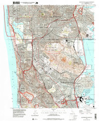
1995 Map of San Francisco South
USGS Topo · Published 1999About this map
Colma and the surrounding San Mateo County hillsides are defined by a dense concentration of historical burial grounds, including Holy Cross Cemetery, Cypress Lawn Cem, and the Italian Cemetery. This 1995 revision reveals a landscape shaped by mid-century suburban expansion and major regional landmarks, from the Cow Palace in Bayshore to Candlestick Park Stadium on the edge of San Francisco Bay. The map traces the rugged contours of San Bruno Mountain and the residential grids of Daly City and South San Francisco. It also preserves the historical footprint of former Spanish land grants like Buri Buri and Cañada de Guadalupe la Visitacion y Rodeo Viejo. Educational and military centers are prominent, including San Francisco State College near Lake Merced and the Marine Corps Supply Annex near the northern boundary.
Find a feature on this map
64 named features on this map. Tap any name to fly to it.
Don’t see what you’re looking for? This feature index may not catch every label — zoom into the map to look around manually.
Map Details
Editions of this 1995 San Francisco South Map
This is the sole edition of this map. No revisions or reprints were ever made.
Other maps of this area

1892 · San Mateo
USGS Topo · 1:62,500

1895 · San Francisco
USGS Topo · 1:62,500

1896 · San Mateo
USGS Topo · 1:62,500

1897 · Tamalpais
USGS Topo · 1:62,500

1899 · San Francisco
USGS Topo · 1:62,500

1899 · San Mateo
USGS Topo · 1:62,500

1915 · San Mateo
USGS Topo · 1:62,500

1915 · San Francisco
USGS Topo · 1:62,500

1939 · San Mateo
USGS Topo · 1:62,500

1941 · Tamalpais
USGS Topo · 1:62,500