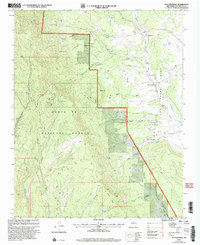
2002 Map of San Geronimo
USGS Topo · Published 2003About this map
San Geronimo and San Pablo sit along the eastern edge of this terrain, where the foothills meet the Grant Las Vegas boundary. The landscape is dominated by the high ridges of the Santa Fe National Forest, rising toward peaks such as Bartilas Peak and the El Barro Peaks. This map traces a transition from the structured forest land and its associated Lookout Tower to the ranching and settlement patterns found in the drainage basins of Tecolote Creek and Tres Hermanos Creek. Local resource extraction and land use are evident in the presence of a Mine and Mineral Hill, while the remote Shearer Ranch sits deep within the canyon systems. Family and local history researchers can identify specific sites like the Cem near San Geronimo and follow old roads that cut through Morse Canyon and Dead Horse Canyon.
Find a feature on this map
30 named features on this map. Tap any name to fly to it.
Don’t see what you’re looking for? This feature index may not catch every label — zoom into the map to look around manually.
Map Details
Editions of this 2002 San Geronimo Map
This is the sole edition of this map. No revisions or reprints were ever made.
Other maps of this area

1889 · Las Vegas
USGS Topo · 1:125,000

1889 · Santa Fe
USGS Topo · 1:125,000

1890 · Bernal
USGS Topo · 1:125,000

1891 · Bernal
USGS Topo · 1:125,000

1891 · Las Vegas
USGS Topo · 1:125,000

1893 · Las Vegas
USGS Topo · 1:125,000

1894 · Santa Fe
USGS Topo · 1:125,000

1894 · Bernal
USGS Topo · 1:125,000

1894 · Lamy
USGS Topo · 1:125,000

1954 · Santa Fe
USGS Topo · 1:250,000