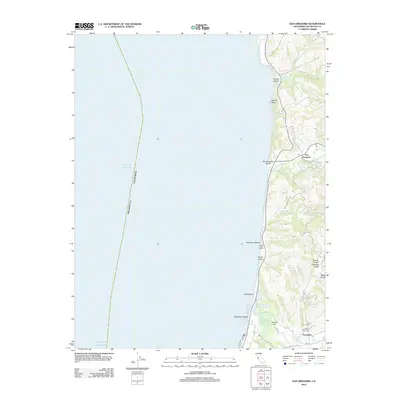
2012 Map of San Gregorio
USGS Topo · Published 2012About this map
Pescadero and San Gregorio anchor this coastal survey, where the Santa Cruz Mountains meet the Pacific shoreline. The landscape is defined by a series of deep drainages, including Tunitas Cr, Pomponio Cr, and San Gregorio Cr, which carve through the coastal terrace to reach the sea at points like San Gregorio Beach and Pescadero Beach. The map details a rural infrastructure of winding roads such as Stage Rd and Tunitas Creek Rd, reflecting a long history of agricultural and timber activity. Local genealogy is supported by the inclusion of Mount Hope Cem and Saint Anthony Cem near the southern edge of the sheet. Further inland, named features like Round Hill and various gulches—Tahana Gulch, Chandler Gulch, and Dairy Gulch—trace the complex topography that historically isolated these coastal enclaves from the more urbanized peninsula to the east.
Find a feature on this map
32 named features on this map. Tap any name to fly to it.
Don’t see what you’re looking for? This feature index may not catch every label — zoom into the map to look around manually.
Map Details
Editions of this 2012 San Gregorio Map
This is the sole edition of this map. No revisions or reprints were ever made.
Other maps of this area

1902 · Santa Cruz
USGS Topo · 1:125,000

1940 · Halfmoon Bay
USGS Topo · 1:62,500

1940 · Ano Nuevo
USGS Topo · 1:62,500

1941 · Ano Nuevo Pt.
USGS Topo · 1:62,500

1942 · Ano Nuevo
USGS Topo · 1:62,500

1943 · Halfmoon Bay
USGS Topo · 1:62,500

1947 · San Francisco
USGS Topo · 1:250,000

1948 · San Francisco
USGS Topo · 1:250,000

1948 · Ano Nuevo
USGS Topo · 1:62,500
1952 · Half Moon Bay
USGS Topo · 1:24,000