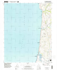
1997 Map of San Gregorio
USGS Topo · Published 1999About this map
The coastal village of San Gregorio serves as a focal point for this section of the San Mateo County shoreline in the late 1990s. The landscape is defined by its Spanish land grant heritage, with clear delineations for the San Gregorio (Rodriguez) Grant and the San Antonio Or Pescadero Grant. These boundaries reflect the deep-rooted agricultural and pastoral history of the region, where roads like Stage Road follow the winding topography toward the community of Pescadero in the south.
Find a feature on this map
31 named features on this map. Tap any name to fly to it.
Don’t see what you’re looking for? This feature index may not catch every label — zoom into the map to look around manually.
Map Details
Editions of this 1997 San Gregorio Map
This is the sole edition of this map. No revisions or reprints were ever made.
Other maps of this area

1902 · Santa Cruz
USGS Topo · 1:125,000

1940 · Halfmoon Bay
USGS Topo · 1:62,500

1940 · Ano Nuevo
USGS Topo · 1:62,500

1941 · Ano Nuevo Pt.
USGS Topo · 1:62,500

1942 · Ano Nuevo
USGS Topo · 1:62,500

1943 · Halfmoon Bay
USGS Topo · 1:62,500

1947 · San Francisco
USGS Topo · 1:250,000

1948 · San Francisco
USGS Topo · 1:250,000

1948 · Ano Nuevo
USGS Topo · 1:62,500
1952 · Half Moon Bay
USGS Topo · 1:24,000