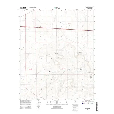
2013 Map of San Ignacio
USGS Topo · Published 2013About this map
San Ignacio and the surrounding high plains of Guadalupe County are defined by a network of drainage arroyos and remote ranching outposts. This early 21st-century landscape shows a community centered around the San Ignacio Cem and the winding Pintada Arroyo, which cuts through the limestone-cradled terrain. The northern portion of the map is dominated by transportation corridors where Vegas Junction marks the convergence of modern highway systems near Bibbs Ranch. The local geography is etched with Spanish-named landforms like Rincon de la Manzanita and Rincon de Ebaristo, reflecting the deep cultural heritage of the Pecos River valley region. Away from the primary roads like Pintada Rd and Copeland Rd, the land remains largely open, characterized by seasonal water features such as Cañada Bonita and the isolated Bull Lake.
Find a feature on this map
22 named features on this map. Tap any name to fly to it.
Don’t see what you’re looking for? This feature index may not catch every label — zoom into the map to look around manually.
Map Details
Editions of this 2013 San Ignacio Map
This is the sole edition of this map. No revisions or reprints were ever made.
Other maps of this area

1890 · Bernal
USGS Topo · 1:125,000

1891 · Bernal
USGS Topo · 1:125,000

1892 · Corazon
USGS Topo · 1:125,000

1894 · Corazon
USGS Topo · 1:125,000

1894 · Bernal
USGS Topo · 1:125,000

1954 · Santa Fe
USGS Topo · 1:250,000

1954 · Fort Sumner
USGS Topo · 1:250,000

1958 · Fort Sumner
USGS Topo · 1:250,000

1958 · Santa Fe
USGS Topo · 1:250,000

1963 · Colonias
USGS Topo · 1:24,000