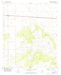
1978 Map of San Ignacio
USGS Topo · Published 1978About this map
San Ignacio serves as a focal point for this high-desert landscape in Guadalupe County, where water and topography dictate the pattern of human activity. The terrain is deeply inscribed by seasonal drainages and canyons, including the significant Arroyo Pintada and the winding Puerto del Haspe. Near the center of the survey, the San Ignacio Cem sits as a quiet landmark of local genealogy, while the presence of the Pintada Mine and a labeled Drill Hole point to the area's geological prospecting history. To the north, Vegas Junction marks a key transit point across the open country, while the Bibbs Ranch and Bull Lake highlight the intersection of private landholdings and essential water sources in this arid region.
Find a feature on this map
18 named features on this map. Tap any name to fly to it.
Don’t see what you’re looking for? This feature index may not catch every label — zoom into the map to look around manually.
Map Details
Editions of this 1978 San Ignacio Map
This is the sole edition of this map. No revisions or reprints were ever made.
Other maps of this area

1890 · Bernal
USGS Topo · 1:125,000

1891 · Bernal
USGS Topo · 1:125,000

1892 · Corazon
USGS Topo · 1:125,000

1894 · Corazon
USGS Topo · 1:125,000

1894 · Bernal
USGS Topo · 1:125,000

1954 · Santa Fe
USGS Topo · 1:250,000

1954 · Fort Sumner
USGS Topo · 1:250,000

1958 · Fort Sumner
USGS Topo · 1:250,000

1958 · Santa Fe
USGS Topo · 1:250,000

1963 · Colonias
USGS Topo · 1:24,000