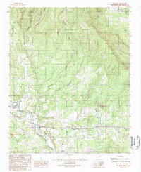
1989 Map of San Jose
USGS Topo · Published 1989About this map
The Pecos River valley defines this late-20th-century landscape, carving a fertile corridor through the high terrain of the Santa Fe National Forest. This 1989 provisional survey details a string of small, historical settlements including San Jose, Ribera, El Ancon, and Soham, many of which follow the essential path of the Atchison Topeka and Santa Fe railroad. The mapping shows a complex system of local water management, with San Jose Dam and Ribera Dam supporting the valley's irrigation needs via a network labeled simply as Ditch. Outside the river bottom, the terrain is marked by steep canyons such as Canyon de las Caraneras and Telephone Canyon. Evidence of local industry is visible in the Priest Mine to the north and several Gravel Pits near the river, while the San Bacino Ch remains a central landmark for the San Jose community.
Find a feature on this map
44 named features on this map. Tap any name to fly to it.
Don’t see what you’re looking for? This feature index may not catch every label — zoom into the map to look around manually.
Map Details
Editions of this 1989 San Jose Map
This is the sole edition of this map. No revisions or reprints were ever made.
Other maps of this area

1889 · Las Vegas
USGS Topo · 1:125,000

1889 · Santa Fe
USGS Topo · 1:125,000

1890 · Bernal
USGS Topo · 1:125,000

1891 · Bernal
USGS Topo · 1:125,000

1891 · Las Vegas
USGS Topo · 1:125,000

1893 · Las Vegas
USGS Topo · 1:125,000

1894 · Santa Fe
USGS Topo · 1:125,000

1894 · Bernal
USGS Topo · 1:125,000

1894 · Lamy
USGS Topo · 1:125,000

1954 · Santa Fe
USGS Topo · 1:250,000