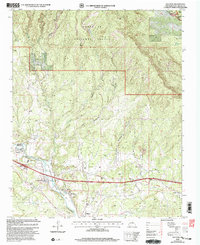
2002 Map of San Jose
USGS Topo · Published 2003About this map
The Pecos River valley defines the character of this New Mexico landscape, where the historic San Miguel Del Bado Tract No 2 reflects the complex legacy of Spanish land grants. Settlements such as San Jose, Ribera, and El Ancon are concentrated along the river's fertile corridor, supported by a network of ditches and springs like Dinks Spring. The transportation history of the region is exceptionally layered, showing the physical intersection of the Santa Fe National Historic Trail and the industrial-era Atchison Topeka and Santa Fe RR. To the north, the terrain climbs into the Santa Fe National Forest, where steep canyons such as Lucero Canyon and Madera Canyon give way to upland features including the Priest Mine. This 2002 revision provides a look at the enduring community patterns and land divisions within the historic Las Vegas Grant.
Find a feature on this map
36 named features on this map. Tap any name to fly to it.
Don’t see what you’re looking for? This feature index may not catch every label — zoom into the map to look around manually.
Map Details
Editions of this 2002 San Jose Map
This is the sole edition of this map. No revisions or reprints were ever made.
Other maps of this area

1889 · Las Vegas
USGS Topo · 1:125,000

1889 · Santa Fe
USGS Topo · 1:125,000

1890 · Bernal
USGS Topo · 1:125,000

1891 · Bernal
USGS Topo · 1:125,000

1891 · Las Vegas
USGS Topo · 1:125,000

1893 · Las Vegas
USGS Topo · 1:125,000

1894 · Santa Fe
USGS Topo · 1:125,000

1894 · Bernal
USGS Topo · 1:125,000

1894 · Lamy
USGS Topo · 1:125,000

1954 · Santa Fe
USGS Topo · 1:250,000