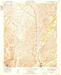
1949 Map of San Juan Capistrano
USGS Topo · Published 1949About this map
San Juan Capistrano serves as the focal point of this coastal California study, anchored by the historic Mission near the confluence of Arroyo Trabuco and San Juan Creek. The landscape of the late 1940s is characterized by expansive ranch lands and open hills, including the Niguel Hills and Sheep Hills, before the onset of modern suburban development. To the north, the settlement of El Toro and the siding at Galivan follow the path of the Atchison Topeka and Santa Fe railroad, which provided a vital transportation link for the region's agricultural output.
Find a feature on this map
25 named features on this map. Tap any name to fly to it.
Don’t see what you’re looking for? This feature index may not catch every label — zoom into the map to look around manually.
Map Details
Editions of this 1949 San Juan Capistrano Map
This is the sole edition of this map. No revisions or reprints were ever made.
Other maps of this area

1896 · Santa Ana
USGS Topo · 1:62,500

1901 · Southern California Sheet No. 1
USGS Topo · 1:250,000

1901 · Santa Ana
USGS Topo · 1:62,500

1902 · Capistrano
USGS Topo · 1:125,000

1902 · Corona
USGS Topo · 1:125,000

1904 · Southern California Sheet No. 2
USGS Topo · 1:250,000

1904 · Southern California Sheet No. 1
USGS Topo · 1:250,000

1906 · Capistrano
USGS Topo · 1:125,000

1932 · Tustin
USGS Topo · 1:31,680
1935 · Tustin
USGS Topo · 1:31,680