
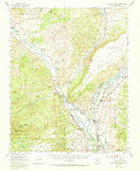
1953 Map of San Juan Pueblo
USGS Topo · Published 1956About this map
Rio Chama and Rio Grande converge in this northern New Mexico landscape, shaping a corridor of historical land grants and traditional agriculture in the early 1950s. The complex system of communal lands is documented through the San Juan Pueblo Grant, Lobato Grant, and Sebastian Martin Grant, illustrating the region's deep-rooted Spanish and Puebloan heritage. Along the riverbanks, small settlements like Hernandez and Chili are connected by a network of acequias, labeled here as Ditch, which have long sustained local farming. Spiritual life is centered at sites such as San Antonio Church and the Immaculate Conception Ch. Traces of earlier transportation appear via the Old Railroad Grade, while the rugged geography is marked by landmarks like Vallito Peak and the dark silhouette of Black Mesa. The presence of the Torreon Indian Shop and various Cem (cemeteries) provides specific points of interest for genealogists and local historians.
Find a feature on this map
88 named features on this map. Tap any name to fly to it.
Don’t see what you’re looking for? This feature index may not catch every label — zoom into the map to look around manually.
Map Details
Editions of this 1953 San Juan Pueblo Map
2 editions found
Other maps of this area

1889 · Santa Fe
USGS Topo · 1:125,000

1892 · Santa Clara
USGS Topo · 1:125,000

1894 · Santa Fe
USGS Topo · 1:125,000

1918 · Abiquiu
USGS Topo · 1:125,000

1952 · Puye
USGS Topo · 1:24,000

1952 · Guaje Mountain
USGS Topo · 1:24,000

1953 · Espanola
USGS Topo · 1:24,000

1953 · Chili
USGS Topo · 1:24,000

1953 · Abiquiu
USGS Topo · 1:24,000

1953 · Medanales
USGS Topo · 1:24,000