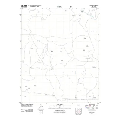
2011 Map of San Juan
USGS Topo · Published 2011About this map
Cedar Hill and the upper reaches of the Pecos River define this corner of San Miguel County, where a network of family-run operations like the JT Gallegos Ranch and Quintana Ranch anchors the landscape. The terrain is deeply inscribed by canyons and mesas, including the prominent Ciruela Mesa and La Cabra Mesa, which overlook seasonal watercourses such as Cañada Segura and Cañada los Rincones.
Find a feature on this map
44 named features on this map. Tap any name to fly to it.
Don’t see what you’re looking for? This feature index may not catch every label — zoom into the map to look around manually.
Map Details
Editions of this 2011 San Juan Map
This is the sole edition of this map. No revisions or reprints were ever made.
Other maps of this area

1890 · Bernal
USGS Topo · 1:125,000

1891 · Bernal
USGS Topo · 1:125,000

1894 · Bernal
USGS Topo · 1:125,000

1954 · Santa Fe
USGS Topo · 1:250,000

1958 · Santa Fe
USGS Topo · 1:250,000

1960 · Villanueva
USGS Topo · 1:62,500

1960 · Apache Springs
USGS Topo · 1:62,500

1963 · Jacinto Mesa
USGS Topo · 1:24,000
1963 · Anton Chico
USGS Topo · 1:24,000
1963 · Mesa Palo Amarillo
USGS Topo · 1:24,000