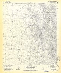
1978 Map of San Juan Spring
USGS Topo · Published 1979About this map
The Baboquivari Mountains dominate the landscape of the Papago Indian Reservation in this 1970s topographic study. The area is defined by a series of drainage networks including the San Juan Wash, Kug Wash, and Ali Molina Wash, which carve through the arid terrain toward the Baboquivari Valley. Evidence of habitation and historical use is scattered throughout the slopes, notably at the Pavo Kug (Ruins) and the settlement at Gu Chuapo.
Find a feature on this map
17 named features on this map. Tap any name to fly to it.
Don’t see what you’re looking for? This feature index may not catch every label — zoom into the map to look around manually.
Map Details
Editions of this 1978 San Juan Spring Map
This is the sole edition of this map. No revisions or reprints were ever made.
Other maps of this area

1934 · Silver Bell
USGS Topo · 1:125,000

1937 · Comobabi
USGS Topo · 1:48,000

1938 · San Vicente
USGS Topo · 1:62,500

1941 · San Vicente
USGS Topo · 1:62,500

1941 · Baboquivari Peak
USGS Topo · 1:62,500

1941 · Sells
USGS Topo · 1:62,500

1942 · San Vicente
USGS Topo · 1:62,500

1942 · Comobabi
USGS Topo · 1:62,500

1943 · Sells
USGS Topo · 1:62,500

1943 · Fresnal
USGS Topo · 1:125,000