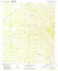
1979 Map of San Juan Spring
USGS Topo · Published 1979About this map
The Papago Indian Reservation landscape is defined by the sharp transition between the Baboquivari Valley and the rising peaks of the Baboquivari Mountains and Quinlan Mountains. This 1970s record detail a network of essential water sources in a desert environment, including San Juan Spring, Vicente Spr, and numerous wells such as Well 3436. Evidence of historical habitation and land use is present at Pavo Kug (Ruins) and the Gu Chuapo Corral, while the local topography is carved by drainages like Ali Molina Wash and San Juan Wash. Several small-scale mining efforts are noted by scattered Prospect labels and Prospects, particularly along the canyon walls. The map provides a look at the desert's infrastructure, from a lonely Grave near a southern dam to a network of Jeep Trails that connect these remote points within the reservation.
Find a feature on this map
25 named features on this map. Tap any name to fly to it.
Don’t see what you’re looking for? This feature index may not catch every label — zoom into the map to look around manually.
Map Details
Editions of this 1979 San Juan Spring Map
This is the sole edition of this map. No revisions or reprints were ever made.
Other maps of this area

1934 · Silver Bell
USGS Topo · 1:125,000

1937 · Comobabi
USGS Topo · 1:48,000

1938 · San Vicente
USGS Topo · 1:62,500

1941 · San Vicente
USGS Topo · 1:62,500

1941 · Baboquivari Peak
USGS Topo · 1:62,500

1941 · Sells
USGS Topo · 1:62,500

1942 · San Vicente
USGS Topo · 1:62,500

1942 · Comobabi
USGS Topo · 1:62,500

1943 · Sells
USGS Topo · 1:62,500

1943 · Fresnal
USGS Topo · 1:125,000