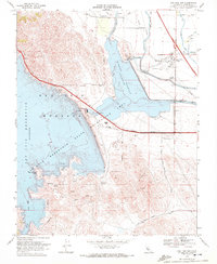
1969 Map of San Luis Dam
USGS Topo · Published 1972About this map
San Luis Dam and the massive impoundment of the San Luis Reservoir dominate this landscape, reflecting a transformative era in California water management. The survey documents the newly established hydrological infrastructure, including the O'Neill Dam, the California Aqueduct, and the Delta-Mendota Canal, which reshaped the terrain around Santa Nella Village. Beyond the massive concrete and water works, the map captures the local human geography of the late 1960s, showing the Romero Sch and the Fore Bay Golf Club alongside the San Luis Gonzaga State Recreation Area. Dramatic elevation changes are evident from the heights of Basalt Hill and Quien Sabe Point, while specialized industrial markers like the Pumping-Generating Plant and Intake Structure reveal the technical complexity of the reservoir project shortly after its completion.
Find a feature on this map
38 named features on this map. Tap any name to fly to it.
Don’t see what you’re looking for? This feature index may not catch every label — zoom into the map to look around manually.
Map Details
Editions of this 1969 San Luis Dam Map
3 editions found
Other maps of this area

1913 · Panoche
USGS Topo · 1:125,000

1919 · Ingomar
USGS Topo · 1:31,680

1920 · Pacheco Pass
USGS Topo · 1:62,500

1920 · Carrisalito Spring
USGS Topo · 1:31,680

1921 · Volta
USGS Topo · 1:31,680

1922 · Quien Sabe
USGS Topo · 1:62,500

1922 · San Luis Creek
USGS Topo · 1:31,680

1922 · Ortigalita
USGS Topo · 1:31,680

1922 · Howard Ranch
USGS Topo · 1:31,680

1940 · Pacheco Pass
USGS Topo · 1:62,500