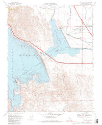
1969 Map of San Luis Dam
USGS Topo · Published 1980About this map
San Luis Dam and the O'Neill Dam dominate this landscape, illustrating the massive scale of California’s water infrastructure as it stood in the late 1960s. The map captures the engineered meeting point of the California Aqueduct and the San Luis Canal, feeding the expansive waters of the San Luis Reservoir and O'Neill Forebay. While the hydraulic works and the Pumping Generating Plant are the primary focus, the human footprint is visible at Santa Nella Village and the Four Bay Golf Club. Local relief is defined by landmarks like Basalt Hill and Quien Sabe Point, while the San Luis State Recreation Area surrounds the shoreline. This record provides a clear view of the region after the primary dams were completed but before decades of further central valley development altered the surrounding transit corridors.
Find a feature on this map
33 named features on this map. Tap any name to fly to it.
Don’t see what you’re looking for? This feature index may not catch every label — zoom into the map to look around manually.
Map Details
Editions of this 1969 San Luis Dam Map
3 editions found
Other maps of this area

1913 · Panoche
USGS Topo · 1:125,000

1919 · Ingomar
USGS Topo · 1:31,680

1920 · Pacheco Pass
USGS Topo · 1:62,500

1920 · Carrisalito Spring
USGS Topo · 1:31,680

1921 · Volta
USGS Topo · 1:31,680

1922 · Quien Sabe
USGS Topo · 1:62,500

1922 · San Luis Creek
USGS Topo · 1:31,680

1922 · Ortigalita
USGS Topo · 1:31,680

1922 · Howard Ranch
USGS Topo · 1:31,680

1940 · Pacheco Pass
USGS Topo · 1:62,500