1942 Map of San Luis Obispo
USGS Topo · Published 1948About this map
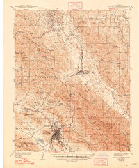
San Luis Obispo serves as the hub of this Central Coast survey, where the Southern Pacific railroad snakes through the Luis Valley before tackling the steep ascent of the Santa Lucia Range. The city is clearly defined by its educational and civic institutions, including the California Polytechnic School and the urban landmark of Terrace Hill. To the north, the planned community of Atascadero is anchored by Atascadero Lake, while the village of Santa Margarita sits at the foot of the critical Cuesta Pass.
Find a feature on this map
89 named features on this map. Tap any name to fly to it.
Don’t see what you’re looking for? This feature index may not catch every label — zoom into the map to look around manually.
Map Details
Editions of this 1942 San Luis Obispo Map
2 editions found

Other maps of this area

1897 · Port Harford
USGS Topo · 1:62,500

1897 · San Luis Obispo
USGS Topo · 1:62,500

1897 · Cayucos
USGS Topo · 1:62,500

1897 · Arroyo Grande
USGS Topo · 1:62,500

1900 · San Luis
USGS Topo · 1:125,000

1914 · Cholame
USGS Topo · 1:125,000

1915 · Cholame
USGS Topo · 1:125,000

1917 · Cholame
USGS Topo · 1:125,000

1919 · Paso Robles
USGS Topo · 1:62,500

1919 · Adelaida
USGS Topo · 1:62,500