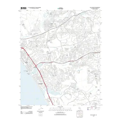
2012 Map of San Luis Rey
USGS Topo · Published 2012About this map
The coastal corridor of northern San Diego County reveals a dense network of suburban development and protected lands along the Pacific Ocean. The historic mission district of San Luis Rey is characterized by the presence of the San Luis Rey Cem and nearby Tacayme, reflecting the area's deep Spanish-era roots near the San Luis Rey River. To the south, the city of Carlsbad and South Oceanside are separated by the ecologically significant Buena Vista Lagoon, while further inland, the landscape rises into named peaks like Cerro de la Calavera and San Francisco Peak. Infrastructure for the growing 21st-century population is well-defined, including the Oceanside Municipal Airport, Miracosta College, and the sprawling Eternal Hills Memorial Park. The map captures the transition from bustling beach communities at Saint Malo Beach to the canyon-cut terrain of Windmill Canyon and Los Monos Canyon near the eastern boundary at Rancho Guajome.
Find a feature on this map
64 named features on this map. Tap any name to fly to it.
Don’t see what you’re looking for? This feature index may not catch every label — zoom into the map to look around manually.
Map Details
Editions of this 2012 San Luis Rey Map
This is the sole edition of this map. No revisions or reprints were ever made.
Other maps of this area

1893 · Oceanside
USGS Topo · 1:62,500

1893 · Escondido
USGS Topo · 1:62,500

1898 · Oceanside
USGS Topo · 1:62,500

1901 · Escondido
USGS Topo · 1:62,500

1901 · Oceanside
USGS Topo · 1:62,500

1901 · San Luis Rey
USGS Topo · 1:125,000

1904 · Southern California Sheet No. 2
USGS Topo · 1:250,000

1941 · Margarita Peak
USGS Topo · 1:62,500

1942 · Margarita Peak
USGS Topo · 1:62,500

1942 · Temecula
USGS Topo · 1:62,500